
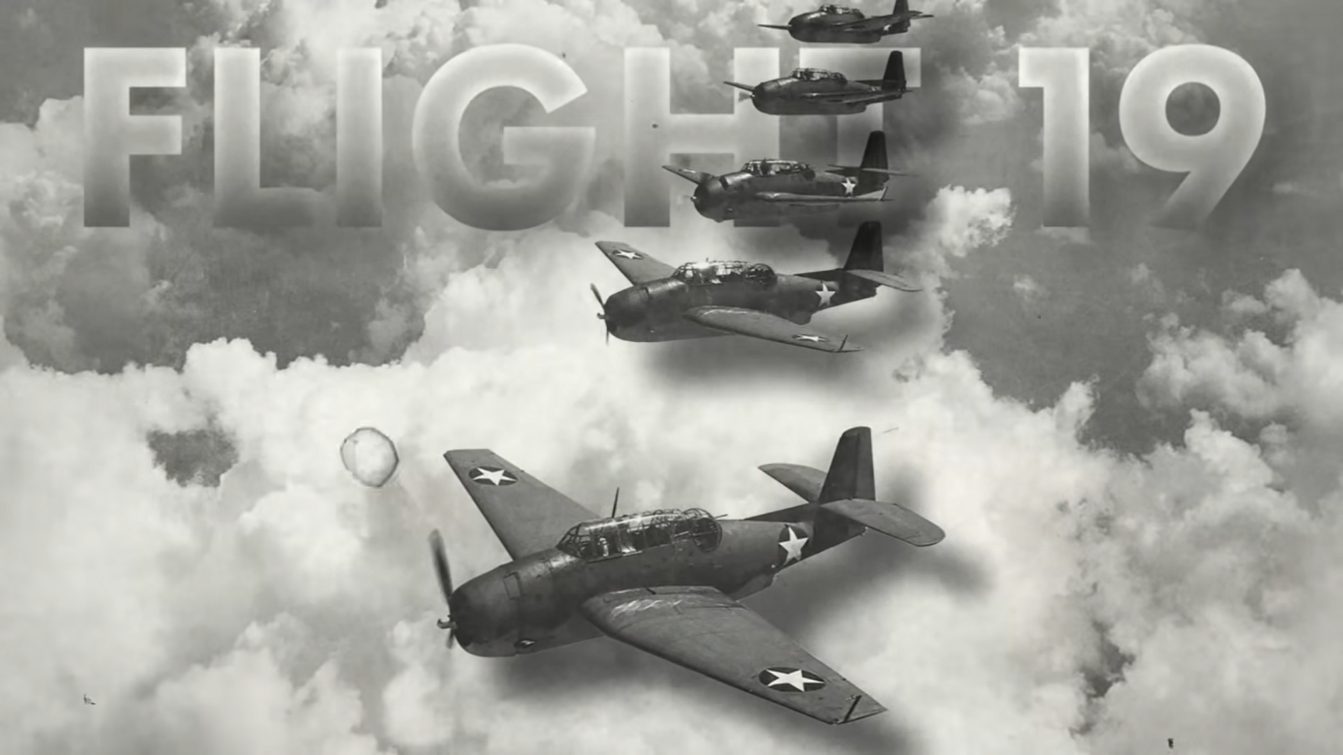
THE BERMUDA TRIANGLE – At 14:10 local time on December 5, 1945, five torpedo aircraft belonging to the United States Navy take off from Florida. This flight, which is designated as Flight 19, is going to carry out a standard training mission that will last for three hours. This flight was not a particularly noteworthy one; rather, it was flying to carry out the duties associated with its routine training mission. There are fourteen members of the flight’s crew.

After approximately two hours of flight, the squadron leaders report that suddenly there is a problem with their compass, their compass stops working, and then they take out the backup compass. Who is being led by the flight leader who is a very experienced pilot and also a war veteran, five planes fly in the direction of the east from Florida. Everything is going normally, the weather is very good. However, the backup compass also stops working, and because they do not know where they are, they ask the pilot of the other portion of the aircraft. However, that pilot’s instrument likewise stops working. Lt Charles Taylor is the head of the squadron, and once the compass is destroyed, several conflicting signals are heard through the radio transmission. Among these communications, Lt Taylor can be heard saying, “both may compasses are out and i am trying to find port Lauderdale, Florida.” I am currently over land, but it is in disarray. I know I’m in the Keys, but I have no idea where I am in relation to the lower keys, and I have no idea how to get to Fort Lauderdale.
At this exact moment in time (4:56), the weather is gradually becoming worse. Taylor realises that his plane has actually flown over the Gulf of Mexico, which means that he must now fly east in order to get back to Florida. He gives the instruction to the rest of the jet to fly east, however there are other flights whose crew believes that they are already in the east. A radio signal can be heard coming from one of the planes almost immediately after this order has been given. “Dammit, if we could just fly west, we could get home; head west dammit,” This suggests that the other members of the party assume that they should fly west in order to return home, but the weather keeps getting worse, the sun goes down, and it grows darker. It is thought that the plane was approximately 370 km east of Florida at this time. The last radio signal from Taylor is received at 7:04 p.m. and it reads as follows: “all planes close up tight, we will have to ditch unless landfall… when first plan drop below 10 gallons, we all go down together.” After then, none of the five planes will ever be seen again. We still do not have any information regarding these aero planes, including where they are or what happened to them.
Following the disappearance of Flight 19, a search and rescue mariner aircraft took off with a group of 13 people. The mission of the aircraft was to fly down Flight 19, but it turned out to be the smoke and it also disappeared. Following the disappearance of the first 14 people of Flight 19 and the 13 people of the search and rescue mariner aircraft, a very large air and sea search operation was called for several days. The largest search operation that had been conducted up to that point to look for these two flights.
There are no traces to be found, no one is located, no human being is located, and no damaged aircraft is discovered. It’s interesting to note that the region where these two planes went missing is now commonly referred to as the Bermuda Triangle. It is stated that the Triangle is a highly strange portion of the ocean where over one hundred aero planes and ships went and vanished; this is such a place that there is no sign of what happened there.
(What exactly is the size of the Bermuda triangle?) a map of the Bermuda triangle

Which results in the formation of a triangle with one side missing across the United States from Florida to Puerto Rico and the nation of Bermuda. The lore surrounding the Bermuda Triangle dates back more than 500 years and encompasses a region that is greater than 500,000 square miles in size. Huh. Christopher Columbus’s compass reportedly stopped functioning while he travelled through the region in 1492, when he was on his way to explore the New World. Columbus’s voyage began that year. And there was a night when he looked up at the sky outside his ship and saw a very strange light, a strange light that looked like a ball of fire, and he saw the ball of fire falling down into the sea. This was the beginning of the mystery, and in the centuries that followed, this location was known by many different names, including the Graveyard of the Atlantic, the Sea of Doom, and the Sargasso Graveyard.
Names like these were common in the 18th and 19th centuries, but the term “Bermuda Triangle” wasn’t coined until 1964, when it appeared in an issue of ARGOSY magazine written by Vincent H. Gaddis. In 1964, Vincent wrote an article for a magazine that was published under the title “The Deadly Bermuda Triangle.” This article is credited with being the first time the name “Bermuda Triangle” was used.
In this piece, he summarized several disappearances that have occurred over the past many decades in this area of the Bermuda Triangle and attempted to link them. Additionally, an attempt was made to make a mystery out of the fact that there is something in the ocean area that is quite large. It is baffling that this phenomenon is responsible for the disappearance of so many planes and ships. There is no explanation offered in the article as to why this is the case; yet, as a result of this, the enigma of the Bermuda Triangle became the most popular riddle during that time period. As a result of this, many films and computer games were based on the book, and even some songs were composed about the Bermuda Triangle. What is the cause behind the events that took place in the Bermuda Triangle – There was a lot about it and some people blamed the aliens that the aliens arrived and took these planes with them, while others believe that it is a large monster that lives underneath the water. The area is congested, and there are rumors going about that all of the planes built in this manner end up falling inside the ship. This is really peculiar.
BERMUDA TRIANGLE THEORY –
We concentrate on those hypotheses on the Bermuda Triangle that have an air of being somewhat more scientific. An explanation is offered on the basis of magnetism, despite the fact that the North Pole of the Earth and the North Pole of the Magnetic Field are two distinct points. , when you look in the direction of north from a compass, it is pointing towards the magnetic north pole, but in actuality, my north pole is a little different, and it is called the geographic north pole. In general, people use compasses, and because they have been doing this since the beginning of time, they take this thing into consideration.
However, there are certain locations on the surface of the globe where, if you use a compass, you will be able to see both the geographic North Pole and the magnetic North Pole in the same location. There is a location where this occurs, they are referred to as Agonic lines, despite the fact that Agonic lines change over time, the zero degree line in the previous 200-300 years has been in the area of the Bermuda Triangle or it is inside of it, which can lead to confusion.
The second element that makes this region unique is that inside the Bermuda Triangle there is a region that is quite shallow. If you look at it on a satellite map, you will notice that it is an island in the Caribbean called the Bahamas, and the region around it can be seen in a turquoise colour. That is to say, there is a very big spread area where the water is not very deep, which is deep sea; the area surrounding it appears to be a dark blue colour, and this region shows out independently when observed from a satellite. It is reported that numerous ships used to arrive here in the olden days, but that they would become stuck due to the shallow water and the concealed shoals. This is because of the reason stated above. If there were any locations under the water where the dirt was emerging a bit more than that, and if such areas were not visible from the outside, then when they walked inside those points, they would have been stranded there at any point.
The United States of America comes in at number two, followed by Cuba, as the third most storm-prone location in the globe. If you look at which country is the most visible throughout the world, China is at the top of the list; however, the United States of America comes in at number two, followed by Cuba. Because of the high frequency of storms and water spouts in this region, which includes Cuba, which is located in this region, and Florida, which is the state with the most hurricanes in the United States and is also located in this region itself, this region contains Cuba. The fourth theory posits that methane hydrates are to blame. In order to test this theory, researchers in Australia conducted a series of laboratory tests in certain parts of the ocean that are known to contain substantial quantities of methane hydrates. He made the observation that the density of the water would decrease and buoyancy would take place if the number of methane bubbles in the water was greater than one in volume. The reasoning is the same: because there is now more salt in the water, the density of the water has increased, and as a result, it is now simpler for items to float on the surface of the water.